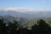
Tansen, Nepal
Place in Lumbini, NepalTansen is a Municipality and the administrative center of Palpa District in the "hills" of central Nepal. It is located on the highway between Butwal and Pokhara, on the crest of the Mahabharat Range or Lesser Himalaya overlooking the valley of the Kaligandaki River to the north. The highway bypasses the town center on the west, protecting pedestrian amenities in the central maze of steep, narrow, winding alleys lined with Newari shophouses and temples.
Read article
Top Questions
AI generatedMore questions
Nearby Places

Palpa District
District in Lumbini Province, Nepal
Barandi
Place in Lumbini Zone, Nepal
Baughapokharathok
Village development committee in Lumbini Zone, Nepal
Chappani
Village development committee in Lumbini Zone, Nepal
Chirtungdhara
Village development committee in Lumbini Zone, Nepal
Telgha
Village development committee in Lumbini Zone, Nepal
Tansen Mission Hospital
Hospital in Palpa, Lumbini, Nepal

Rana Ujeshwori Bhagwati temple
Hindu temple in Nepal


